
Archival item of the month: Nautical chart Paskaart vande Iade, Weser en Elve
In the "Archival item of the month" series, the German Maritime Museum (DSM) / Leibniz Institute of Maritime History presents a special treasure from the archive every month. In May, historian and expert in navigation technology and nautical charts, Dr. Frederic Theis, looks at Johannes van Keulen's 17th century nautical chart "Paskaart vande Iade, Weser en Elve".
In the collection of the German Maritime Museum, a large number of early modern sea and ocean charts bear witness to knowledge transfer processes of the 16th, 17th and 18th centuries relating to the seas and their coasts: to practical orientation, i.e. seafaring with charts, and not least to how shipping as a medium of global networking shaped our world today.
This nautical chart sheet of Dutch origin from around 1690 shows the inner German Bight with Heligoland, the estuaries of the Elbe, Weser and Jade rivers, the Wadden Sea areas off the North Sea and the immediately adjacent mainland. Contrary to current cartographic convention, the map is oriented to the south. Thus the Jade and Weser, the latter in its lower reaches from Bremen, appear in the upper right-hand section of the map, while the Elbe from Hamburg appears in the left-hand half of the sheet. For reasons of space - otherwise the map section would have had to be extended to the left with disproportionate effort - the partial course of the Elbe river between Hamburg and the town of "Haseldorp" (Haseldorf in present-day Schleswig-Holstein) has been moved from the main map to a secondary map bordered by green.
Numerous detailed information identifies the sheet as a navigation chart. For example, a structural distinction is made between the fairways of the rivers and estuaries on the one hand and the surrounding shallow areas of the Wadden Sea on the other. Sandbanks such as "Rode Sandt" and "Hooge Wech" (Roter Sand and Hohe Weg) in the Outer Weser or "Vogel Sand" in the Outer Elbe are clearly outlined in gray. The fairway of the Outer Weser, and to a lesser extent that of the Elbe, is also marked with numerous conical navigation marks - floating buoys - the outermost of which is marked with an X as the Beehr buoy (Birntonne). This pear-shaped buoy, which marks the western reaches of the Rote Sand shallows, also appears to mark the beginning of the fairway and would therefore have been the approach buoy for skippers navigating from the North Sea to the Weser and Bremen. However, the Bremen "key buoy", which is not included in the present map, had already been used as an actual navigation mark in the border area between the North Sea and the Outer Weser since 1664. While it cannot be ruled out that this information did not reach the cartographers based in Amsterdam before the first edition of the map was printed, it is more likely that this was a deliberate decision. For example, Dutch skippers heading for the Weser could have continued to use the older pear buoy as a navigational fixed point.
A complex system of lines covers the map sheet. In addition to the latitude and longitude lines, time-typical rumble lines appear, whose rays spread out across the map sheet in a star shape of wind roses. While the degree grid lines enabled navigators to reference the sea area and the ship's position in the earth's degree grid when using the map, the rumble lines supported practical wayfinding with sailing ships: With the help of these lines, the position of relevant places such as harbor towns or approach buoys could be estimated in relation to each other and a sea voyage or a section of a voyage could be planned in advance with regard to the prevailing winds, currents and tides.
The publisher named in the vignette at the bottom left is the Amsterdam-based cartographer Johannes van Keulen (1654-1715), whose production company "Inde gekroonde Lootsman" was granted a fifteen-year state privilege and exclusive exploitation rights to his nautical charts, atlases and printed sailing instructions in 1680. A prerequisite for the production of charts and their accuracy was reliable and up-to-date information about the conditions in the sea area. On the one hand, this may have come from nautical experts in actual merchant and military shipping, and on the other - and the publisher's name refers to this - from pilots who were also familiar with the coastlines depicted from their own experience. They therefore not only applied their specific knowledge in practice, namely as advisors to the skippers, but also as contributors to map publishers.
The "Paskaart vande Iade, Weser en Elve" is a snapshot of the state of knowledge at the time and a testimony to knowledge production and transfer processes for the direct benefit of shipping. It is also exemplary of the German Maritime Museum's thousands of cartographic archive materials and their relevance to shipping and global history.
(Frederic Theis)
Captions to the illustrations
Figure 1: Paskaart vande Iade, Weser en Elve, general view.
Figure 2: The map section shows the Lower Weser from Bremen and the Outer Weser with the fairway, the floating navigation marks and the shoals.
Figure 3: The map vignette shows the author's name Johannes van Keulen from Amsterdam as well as scale bars in German, Spanish, English and French miles.

Figure 1: Paskaart vande Iade, Weser en Elve, general view. Credit: DSM

The map section shows the Lower Weser from Bremen and the Outer Weser with the fairway, the floating navigation marks and the shallows.
Photo: DSM
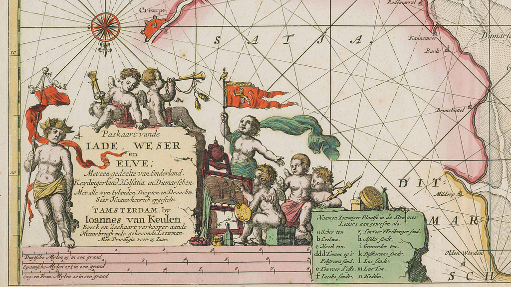
The map vignette shows the author's name Johannes van Keulen from Amsterdam as well as scale bars in German, Spanish, English and French miles.
Photo: DSM